Dunes sagebrush lizard
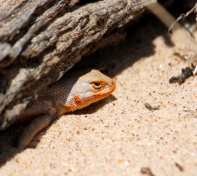
The dunes sagebrush lizard is one of the most imperiled lizards in the United States.
The dunes sagebrush lizard is one of the most imperiled lizards in the United States.
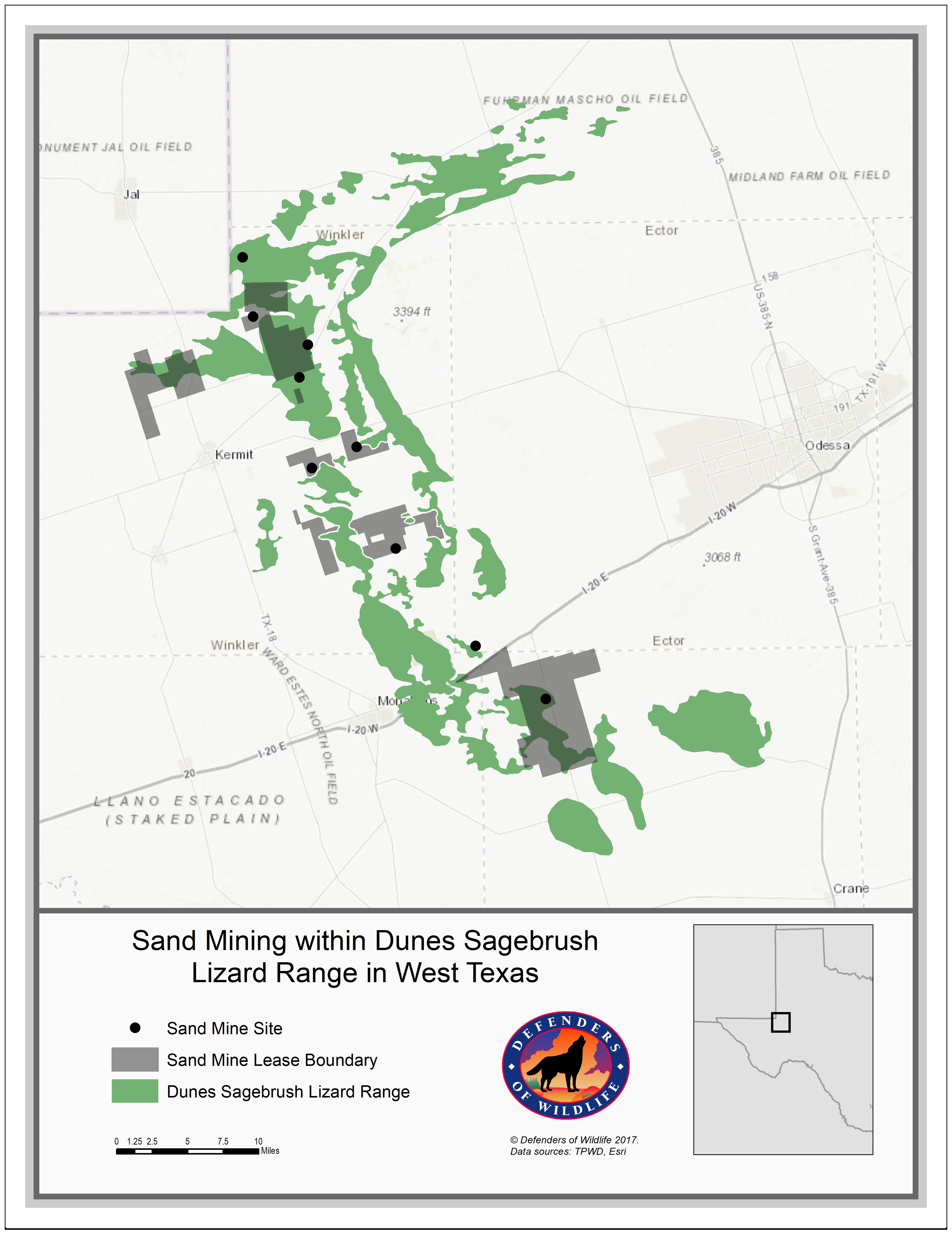
The lizard's habitat patches in Texas (green) combined with the lease boundaries of sand mines (dark gray) and mine sites identified in satellite imagery (dots).
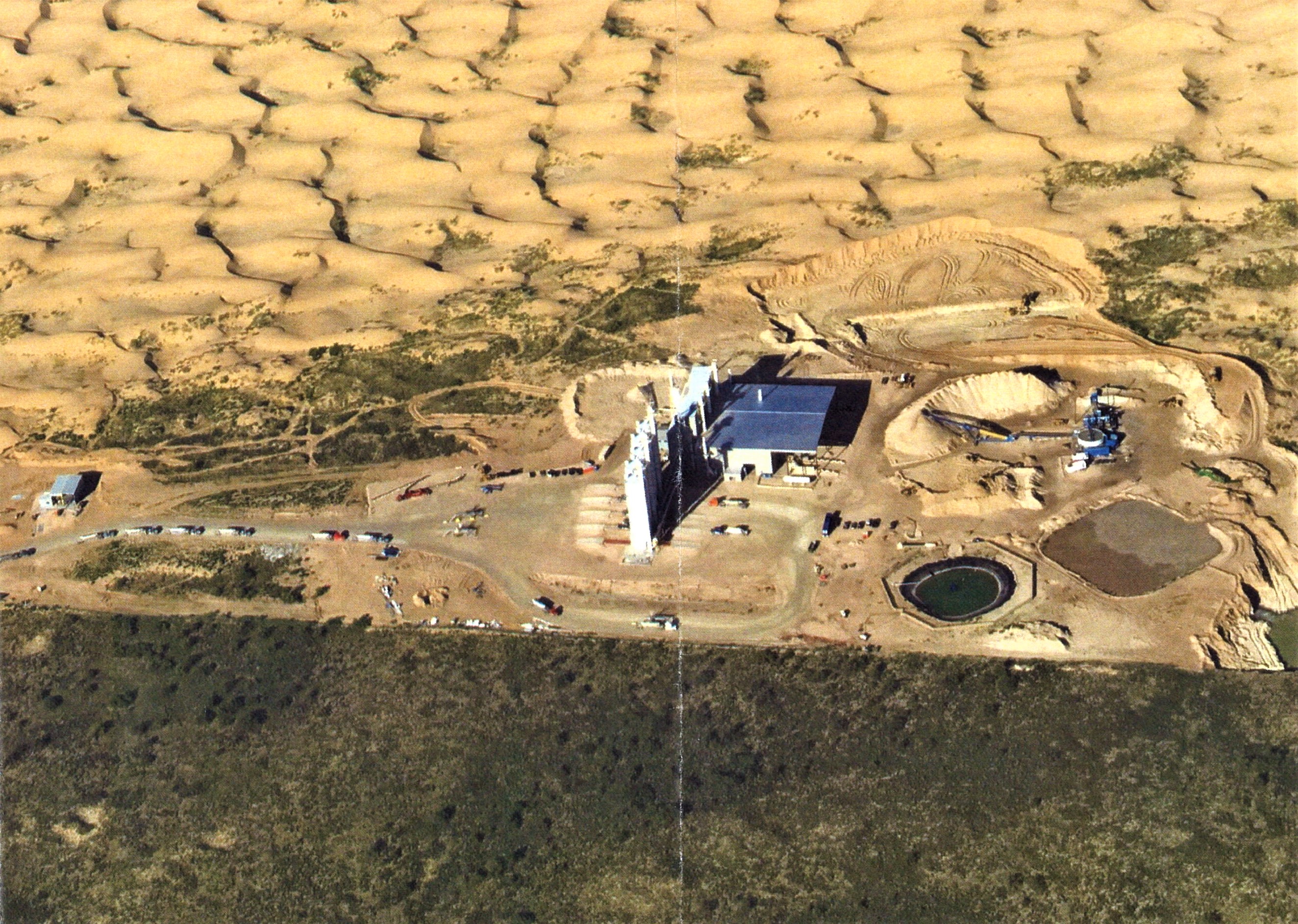
The Hi-Crush mine is sited in and is destroying some of the best dunes sagebrush lizard habitat available.
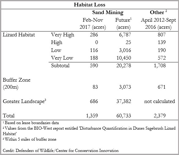
Current and possible future dunes sagebrush lizard habitat losses from various sources.
A sand mine (Hi-Crush) destroying prime dunes sagebrush lizard habitat in Texas.
(Click thumbnails to enlarge)
The dunes sagebrush lizard is one of the most imperiled lizards in the United States, restricted to small segments of New Mexico and Texas. This area is also significant for energy development—oil, gas, and wind—that threatens the lizard’s habitat. Despite the rarity and threats, the U.S. Fish and Wildlife Service (FWS) declined to list the species under the Endangered Species Act in 2012. That decision was based partly on a voluntary conservation plan for the species finalized just months earlier between FWS and the Texas Comptroller of Public Accounts. Under the plan, participants agree to avoid and minimize certain activities that harm the lizard and to restore its habitat. Historically, the primary threat has been habitat loss from energy development. In the last few months, however, sand mining has emerged as a threat to the lizard—one that could overshadow all other threats.
Since its inception, the plan has faced issues with its implementation. Many aspects of the plan are shielded from public review, including information on the location of enrolled properties, the name of participants, and the exact conservation measures a participant promises to carry out. Moreover, surface and mineral rights can be enrolled separately, so it is possible for enrolled areas to still be disturbed by other owners who lease those areas. As a result, the public has difficulty holding plan participants accountable and ensuring the lizard is protected under the plan. Another problem arose in 2013, when we used satellite images to uncover unauthorized and unreported oil and gas development under the plan. And in 2016, the comptroller fired the organization tasked with implementing the plan, because the organization failed to perform any of the habitat restoration work it agreed to do in 2013 and 2014. As of September 2016, 2,378 acres of the lizard’s 248,686 acres of habitat and surrounding buffers had been disturbed under the plan. Of this disturbance, 54 percent (1,287 acres) occurred in areas that were not enrolled in the plan and another 32 percent (776 acres) occurred in enrolled areas by entities that were not participants in the plan.
Sand mines can be even more disruptive than oil and gas development, removing very large swaths of habitat. In West Texas, they have appeared suddenly and can expand quickly. In August 2017, we used satellite images to detect nine sand mining operations in or adjacent to lizard habitat in Texas. These operations provide sand for hydraulic fracking in the region. Neither FWS nor the comptroller anticipated this threat in 2012, so it was never addressed in the Texas plan nor in the decision to decline listing the lizard. The mines broke ground earlier this year and, according to our satellite image analysis, have already disturbed 292 acres of lizard habitat and surrounding buffers. Based on lease data, the mines could eventually disturb or destroy over 23,000 acres (9.5 percent) of the lizard’s habitat and buffer in Texas.
The Texas Comptroller’s Office has asked all the sand mining companies to voluntarily avoid or minimize their impacts on lizard habitat and has had some success. Two companies, Vista Sand and Black Mountain, have modified their plans to avoid lizard habitat and surrounding buffers. But some other companies have not cooperated. Hi-Crush and Atlas Sand Company, for example, own leases that cover 11 percent (6,742 acres) of the highest quality lizard habitat in Texas. As of September 2017, neither company has agreed to modify its operations. Further, we estimate that Fairmount Santrol has already excavated 18 acres of some of the best habitat for the species—we do not know to what extent its operations could expand. Without significant changes to the proposed footprint of these and other mines, lizard populations in Texas could be significantly harmed and listing under the ESA could follow.
At Defenders’ Center for Conservation Innovation, we are using satellite images to track the footprint of all sand mines within or adjacent to lizard habitat. To see monthly images of the sand mines to date, follow the link below to our interactive story map.
Project contributors: Matthew Moskwik, Michael Evans, Jacob Malcom, and Ya-Wei Li
View Story Map Method Summary
This work is licensed by Defenders of Wildlife under a Creative Commons Attribution-NonCommercial-ShareAlike 4.0 International License
.