Abstract
This app helps users understand the costs associated with obtaining a permit for the incidental take of eagles at wind energy facilities. The statistical model used to estimate how many eagles might be harmed at a new facility can be hard to understand in practice, so we let users simulate different scenarios to see how factors like eagle activity, facility size, and pre-construction survey effort can change the costs of obtaining a permit.
In the U.S., wind energy facilities require an incidental take permit to account for any bald and golden eagles that might be killed because of the project’s operation. Developers must mitigate for the incidental take of the predicted number of eagles. Mitigation often involves buying retrofits for power transmission lines that prevent eagles from being electrocuted.
For proposed projects, the
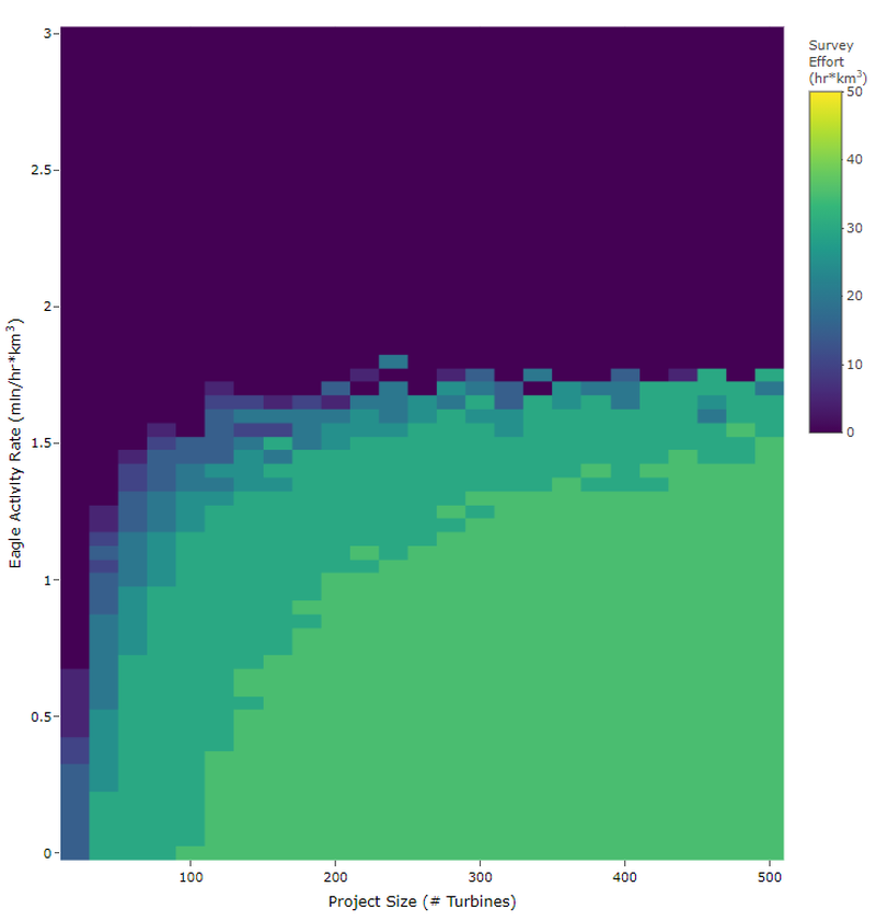
U.S. Fish and Wildlife Service uses a Bayesian model to estimate how many eagles will be killed. Bayesian models combine prior information with new data collected at a proposed site to produce estimates. So the more time spent surveying for eagles at a proposed site, the more closely estimates reflect eagle activity levels at that site (rather than existing sites). This means that the predicted number of eagle fatalities is influenced by five factors: 1. Mitigation cost: cost of power pole retrofits to offset 1 eagle, 2. Survey cost: costs of eagle surveys, 3.Survey effort: time spent collecting eagle activity data, 4. Eagle activity: level of eagle activity at the project site, 5. Project size: number of turbines to be built.
In this app, users can change these parameters to simulate different wind energy facility scenarios and visualize the relationships between survey effort and permitting costs. In some cases, more surveys can actually save developers money. This tool can help regulators and developers identify guidelines for eagle mitigation that balance costs with eagle conservation.

Previous Senior Conservation Data Scientist
As the previous Senior Conservation Data Scientist in the Center for Conservation Innovation at Defenders, Mike led geoinformatics and data science projects to inform and improve conservation.


