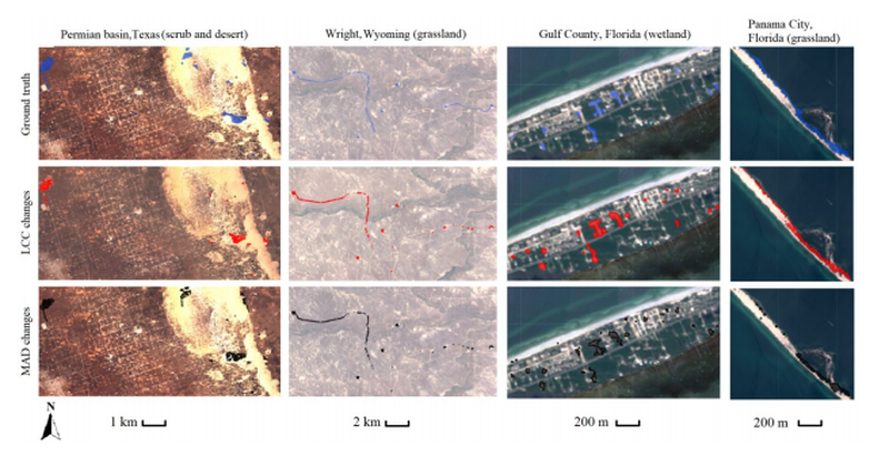
A significant limitation in biodiversity conservation has been the effective implementation of laws and regulations that protect species’ habitats from degradation. Flexible, efficient, and effective monitoring and enforcement methods are needed to help conservation policies realize their full benefit. As remote sensing data become more numerous and accessible, they can be used to identify and quantify land-cover changes and habitat loss. However, these data remain underused for systematic conservation monitoring in part because of a lack of simple tools. We adapted 2 algorithms that automatically identify differences between pairs of images. We used free, publicly available satellite data to evaluate their ability to rapidly detect land-cover changes in a variety of land-cover types . We compared algorithm predictions with ground-truthed results at 100 sites of known change in the United States. We also compared algorithm predictions to manually created polygons delineating anthropogenic change in 4 case studies involving imperiled species’ habitat: oil and gas development in the range of the Greater Sage Grouse (Centrocercus urophasianus); sand mining operations in the range of the dunes sagebrush lizard (Sceloporus arenicolus); loss of Piping Plover (Charadrius melodus) coastal habitat after Hurricane Michael (2018); and residential development in St. Andrew beach mouse (Peromyscus polionotus peninsularis) habitat. Both algorithms effectively discriminated between pixels corresponding to land-cover change and unchanged pixels as indicated by area under a receiver operating characteristic curve >0.90. The algorithm that was most effective differed among the case-study habitat types, and both effectively delineated habitat loss as indicated by low omission (min. = 0.0) and commission (min. = 0.0) rates, and moderate polygon overlap (max. = 47%). Our results showed how these algorithms can be used to help close the implementation gap of monitoring and enforcement in biodiversity conservation.
As the previous Senior Conservation Data Scientist in the Center for Conservation Innovation at Defenders, Mike led geoinformatics and data science projects to inform and improve conservation.