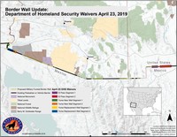
Border Wall: Map of April 23, 2019 DHS Waivers
The Trump Administration has continued to advance work on the border wall between the U.S. and Mexico. Recently, the Department of Homeland Security (DHS) formally announced waivers for new sections of wall in western portions of the border. Here we …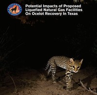
Potential Impacts of Proposed Liquefied Natural Gas Facilities On Ocelot Recovery in Texas
This report was produced by Defenders of Wildlife, with the support of CCI, to detail the effects three proposed liquefied natural gas (LNG) facilities in the Brownsville Ship Channel would have on the future of ocelot recovery in the United States. …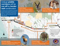
Border Wall: Map of February 2019 DHS-DOD Request
The Trump Administration has continued to advance work on the border wall between the U.S. and Mexico. Recently, the Department of Homeland Security (DHS) made a formal request to the Department of Defense to build extensive new sections of wall in …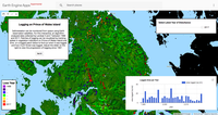
Prince of Wales Island Logging
Deforestation can be monitored from space using Earth observation satellites. For this interactive, an algorithm analyzed data collected by Landsat 5 and 7 between 1988 and 2017. Patches of logging can be visualized by tracking spikes in vegetation …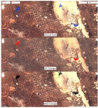
Automated habitat change detection methods using satellite data to improve conservation law implementation.
A significant limitation in biodiversity conservation has been the effective implementation of laws and regulations that protect species habitats from degradation. Flexible, efficient, and effective monitoring and enforcement methods are needed to …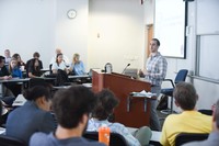
Eye in the Sky: The use of innovative SAR technology and new GIS tools to aid environmental compliance and monitoring.
Eye is the Sky will provide an overview of imaging technology and how it has been used in environmental litigation. The panel will also seek to address why state and federal environmental regulatory agencies have been slow to embrace these …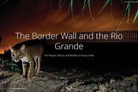
The Border Wall and the Rio Grande
An interactive story map detailing how border wall construction would impact the people, places and wildlife of the Lower Rio Grande Valley (LRGV) in Texas. In the absence of a comprehensive environmental study of the impacts of the border wall, …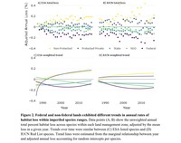
30 years of satellite data show imperiled species are most vulnerable to habitat loss on private lands
To stem the ongoing loss of biodiversity, there is an urgent need to distinguish effective and ineffective approaches to protecting species and their habitats. Conservation laws may be strong on paper but ineffective in practice, or vary in …
ESAdocs Search
Thousands of pages of ESA-related documents are created every year, each containing important and helpful information for conserving species. We've collected over 500,000 pages of these documents and made them fully searchable in this publicly …