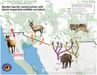
Impacts to Wildlife Along the U.S.-Mexico Border: March 2020 Waivers
The Trump Administration has continued to advance work on the border wall between the U.S. and Mexico. In March 2020, the Department of Homeland Security (DHS) formally announced waivers for new sections of wall along the southern borders of …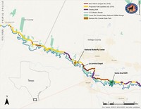
Border Wall: Map of August 30, 2019 DHS Waiver
The Trump Administration has continued to advance work on the border wall between the U.S. and Mexico. Recently, the Department of Homeland Security (DHS) formally announced waivers for new sections of wall along the border in the Lower Rio Grande …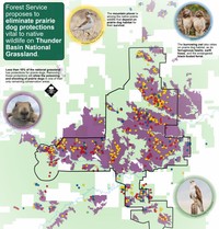
Thunder Basin National Grasslands - U.S. Forest Service's Plan Amendment
The Forest Service released a federal proposed action for amending the Thunder Basin Land and Resource Management Plan. Defenders is opposed to this action because this amendment will remove the prairie dog strategy concerning the core management …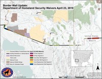
Border Wall: Map of April 23, 2019 DHS Waivers
The Trump Administration has continued to advance work on the border wall between the U.S. and Mexico. Recently, the Department of Homeland Security (DHS) formally announced waivers for new sections of wall in western portions of the border. Here we …
Border Wall: Map of February 2019 DHS-DOD Request
The Trump Administration has continued to advance work on the border wall between the U.S. and Mexico. Recently, the Department of Homeland Security (DHS) made a formal request to the Department of Defense to build extensive new sections of wall in …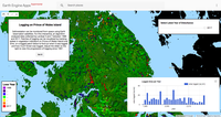
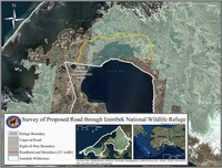
Prince of Wales Island Logging
Deforestation can be monitored from space using Earth observation satellites. For this interactive, an algorithm analyzed data collected by Landsat 5 and 7 between 1988 and 2017. Patches of logging can be visualized by tracking spikes in vegetation …
Monitoring
Monitoring is essential to effective and efficient conservation: we need to know the effects of our actions on wildlife, from the benefits of actions to recover species to the consequences of authorizing harm. Under a law like the U.S. Endangered …